The MTA is committed to making all modes of transit accessible for every customer. That means making 95% of subway stations accessible. It also means testing new technology and features so every rider can stay informed and feel safe and comfortable.
In 2019, we tested 15 new accessibility features as part of the Accessible Station Lab at the Jay St-MetroTech station. We're thrilled to roll out four of the most successful features from the Station Lab to more stations starting in July 2023. The MTA thanks State Senator Brad Hoylman-Sigal of District 47 for generously providing funding for this project.
Look for these features coming to subway stations and bus stops on the west side of Manhattan in 2023 and 2024, and share your feedback with us by emailing accessibility@mtahq.org.
Smartphone apps
NaviLens and NaviLens GO
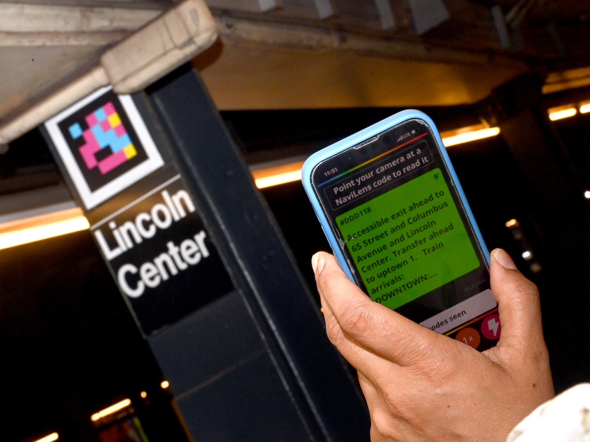
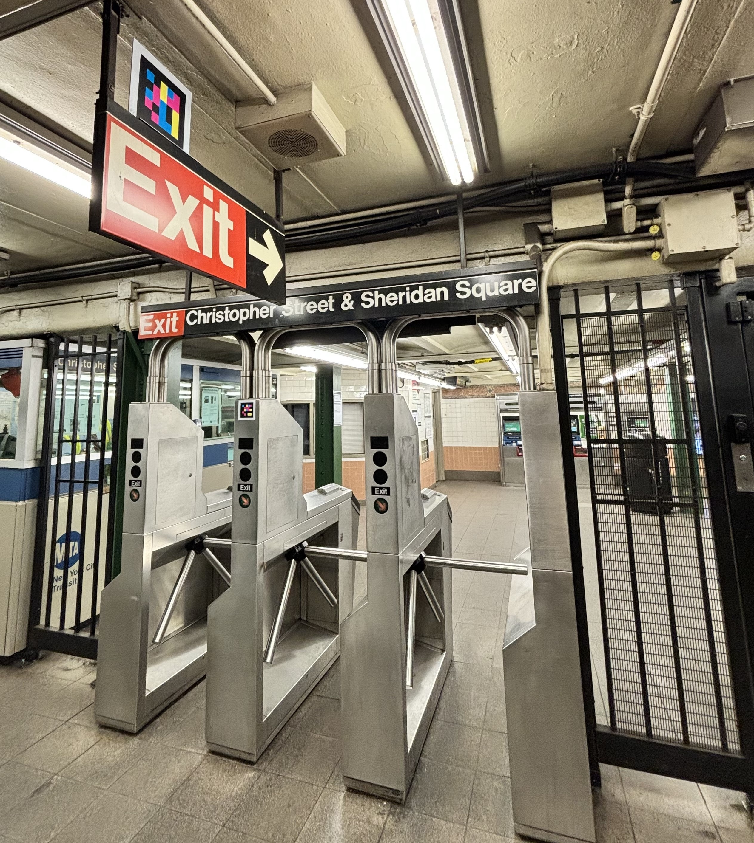
NaviLens and NaviLens GO are free smartphone apps that translate visual information into accessible formats. When you scan a NaviLens code in a subway station or at a bus stop, the app will read out information like train or bus arrival times, real-time elevator status, and information about in-station features. The codes also guide the user to their locations. This can help blind and low-vision riders identify precise bus stop locations, find the subway station AutoGate or HelpPoint, and more. NaviLens can also translate information into dozens of languages, increasing language access.
We've installed nearly 400 NaviLens codes on the entire M66 bus route, throughout the 66 St-Lincoln Center and Christopher St-Sheridan Sq stations and the 72 St station.
You can expect to see NaviLens continue to roll out across the M66 bus route and in stations in District 47 including:
- Houston St
- 14 St
- 8 Av
- 18 St
- 23 St
- 23 St
- 28 St
- 50 St
- 59 St-Columbus Circle
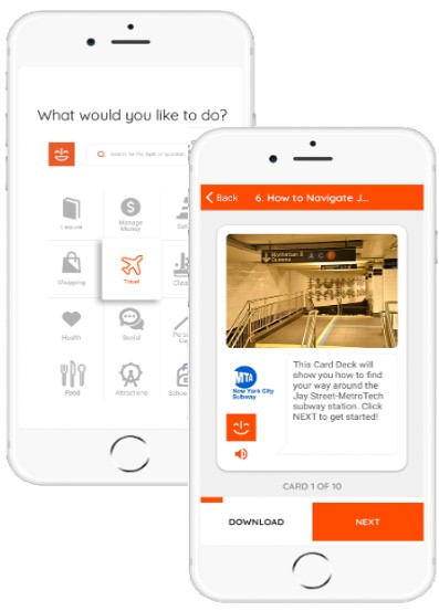
MagnusCards by MagnusMode
MagnusCards is a free smartphone app. It can help customers with cognitive disabilities and anyone who could use extra help navigating everyday experiences. It features an illustrated character named Magnus and combines the specialized instruction of a behavior therapist with real-world images.
Magnus explains experiences through digital Card Decks. These are short how-to guides that are specific to traveling through the NYCT system. Each Card Deck provides step-by-step visual, audio, and text instructions that set expectations and ease anxiety. This will include detailed explanations of stations and experiences in this part of Manhattan.
Signage
Accessible boarding area floor decals
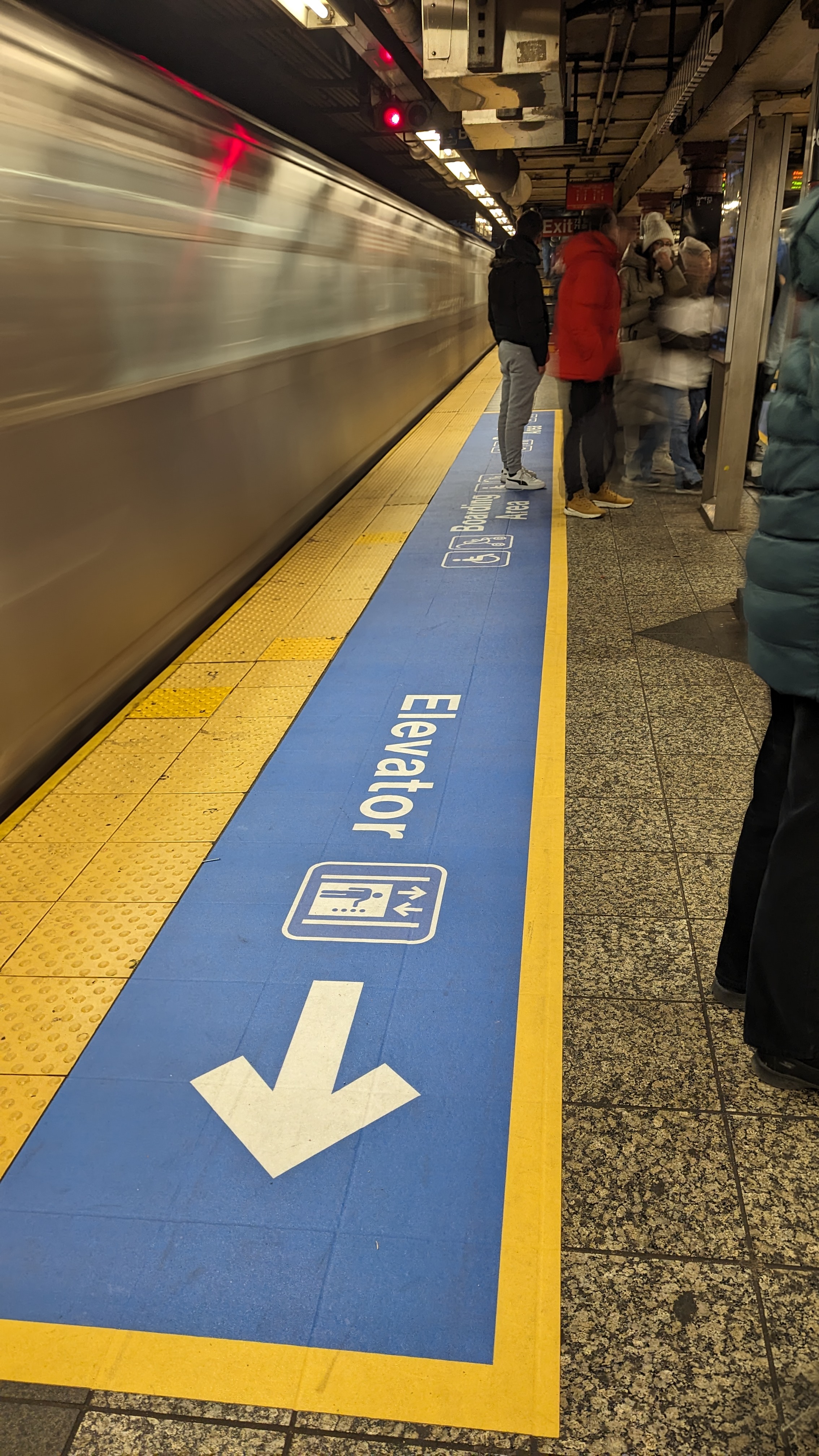
Subway riders who use wheelchairs or walkers need to be especially careful of any gap between the platform and the train. So do riders traveling with luggage, bicycles, or children in strollers. These customers are often looking for the Accessible Boarding Area. That's an area where gaps between the platform and train are minimized to meet accessibility standards.
The Accessible Boarding Area is usually located near the center of the platform, where the conductor’s car stops. But the exact best boarding location can vary by platform. That’s why signing the boarding area is critical. Every accessible station has a sign above the Accessible Boarding Area, but it can be hard to see in a busy station. As part of this project, we're installing large blue and white floor decals with accessibility icons to mark this area. This will make it easier for customers to find this area and let everyone know that customers who use mobility devices may be boarding there.
If you push a stroller or luggage, you may want to board here, but please be mindful of and give priority to customers with disabilities.
You can find these decals at the following stations:
- W 4 St-Wash Sq
- 14 St
- 8 Av
- 1 Av
- 34 St-Hudson Yards
- 34 St-Penn Station
- 34 St-Herald Sq
- 42 St-Port Authority
- Times Sq-42 St
- Grand Central-42 St
- 47-50 Sts-Rockefeller Ctr
- 49 St
- 50 St
- 51 St
- 59 St-Columbus Circle
- 66 St-Lincoln Center
- 72 St
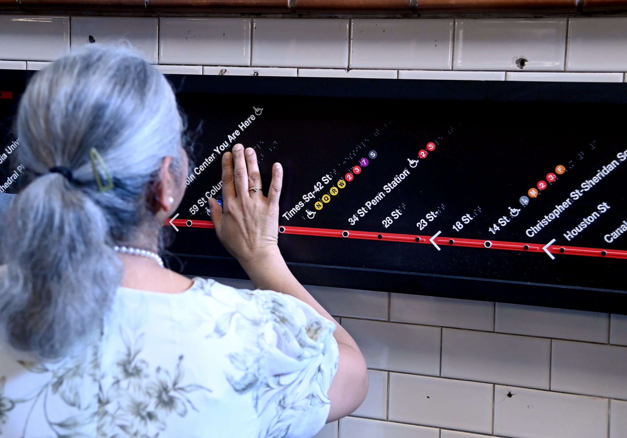
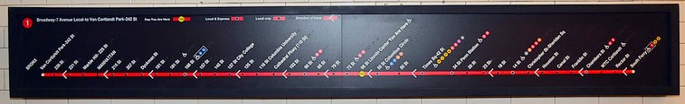
Tactile Braille line maps
These maps provide information on all the stations on the line to blind and low-vision customers who can't easily use a print map or digital screen. They show the rider's location and other important information about each station, like transfers and which stations are accessible.
There are currently two Braille line maps installed at 66 St-Lincoln Center, one for uptown service and one for downtown service. The maps are installed at the mezzanine level near the bottom of the southern staircase at the 66 St entrance to the station. There is a NaviLens code installed near each map to help customers find the map location.
By spring 2024, you'll be able to check out these maps at the following stations:
- 23 St
- 50 St
- 59 St-Columbus Circle
- 66 St-Lincoln Center
We want your feedback!
We hope you'll check out these features, no matter your abilities, and provide us with your feedback! Do you like these features? How can they be improved? Would you use them if they were available systemwide?
Email accessibility@mtahq.org!